Please upgrade your browser to view our current wind and swell buoy map. You will be able to use Bigsalty Weather to its full potential.
Using the current weather map
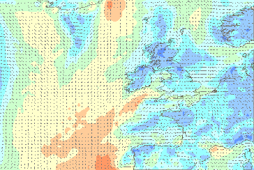
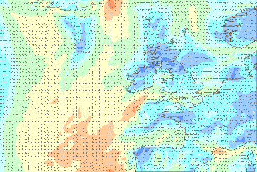
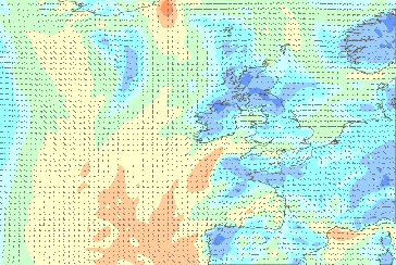
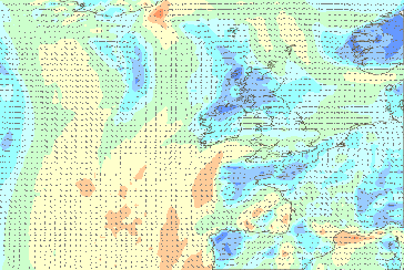
Overview
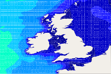
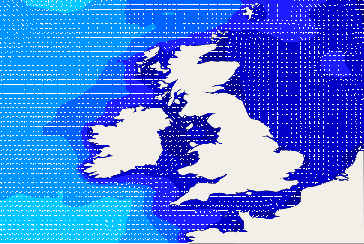
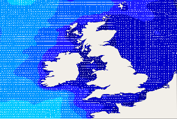
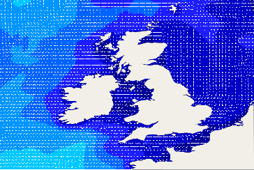
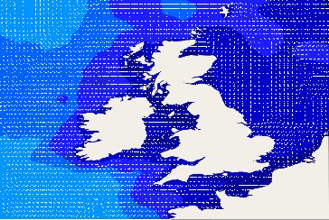
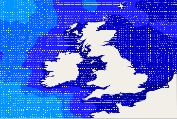
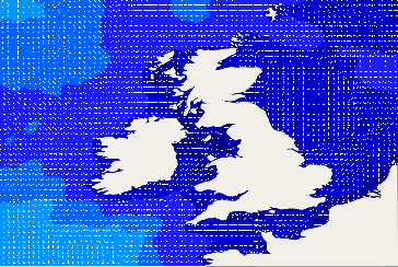
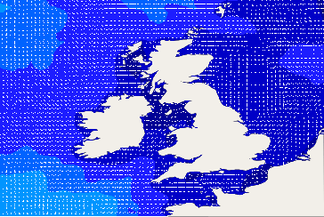
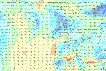
The live wind map shows the current wind state of UK + Ireland. Click or tap the arrows to reveal the data panel and the exact times of the readings. Zoom in by scrolling your mouse within the map area. Move by clicking and dragging.
Swell data
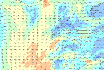
Click on the 'Swell Buoy' tab above the map. If you are using a mobile web browser, you can see this by clicking on the 'Toggle Wind / Swell Buoys' tab. Tap on the icons for more info.
Graph data
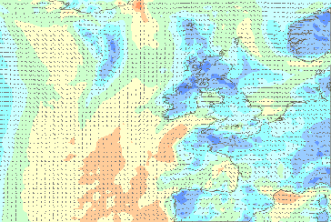
Clicking on the location icons will reveal a graph panel. Each graph panel has several data views that can be seen by clicking on the sub menu within the panel.
Units of measurement
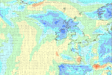
The units used will be determined by the defaults set on your account when logged in.
Oops! There has been a problem
It looks like something went wrong loading the data, please check your internet connection. If the problem persists, please let us know.
The Maze (Argyll)
< SWIPE > | Wind | Gust | Wave | Period | Rain | Cloud | Temp | Chill | Wave Rating | ||
|---|---|---|---|---|---|---|---|---|---|---|---|
| 01:00 | 23.3kts | 26.6kts | | 3.2m | 12.5sec | | -1mm | -1% | 8°C | 2°C |
|
| 04:00 | 21.8kts | 24.7kts | | 2.9m | 12.1sec | | 0.1mm | 6% | 8°C | 3°C |
|
| 07:00 | 18kts | 21.1kts | | 2.5m | 11.8sec | | 0.2mm | 6% | 8°C | 3°C |
|
| 10:00 | 16.7kts | 19.9kts | | 2.2m | 11.3sec | | 0.1mm | 4% | 8°C | 3°C |
|
| 13:00 | 15.3kts | 19.4kts | | 2m | 10.8sec | | 0.1mm | 5% | 8°C | 3°C |
|
| 16:00 | 21.3kts | 25.4kts | | 1.9m | 10.4sec | | 0.3mm | 4% | 8°C | 2°C |
|
First light: 05:33-06:14 / Last light: 20:40-21:21
Select Criteria
Shipping Forecast
AND NOW THE SHIPPING FORECAST ISSUED BY THE MET OFFICE, ON BEHALF OF THE MARITIME AND COASTGUARD AGENCY, AT 0505 UTC ON TUESDAY 16 APRIL 2024 FOR THE PERIOD 0600 UTC TUESDAY 16 APRIL TO 0600 UTC WEDNESDAY 17 APRIL 2024
THERE ARE WARNINGS OF GALES IN FORTIES CROMARTY FORTH TYNE DOGGER GERMAN BIGHT HUMBER THAMES DOVER WIGHT FITZROY FAIR ISLE AND FAEROES
THE GENERAL SYNOPSIS AT MIDNIGHT
LOW NORWEGIAN BASIN 1000 EXPECTED FORTIES 1006 BY MIDNIGHT TONIGHT. LOW GERMAN BIGHT 991 LOSING ITS IDENTITY
THE AREA FORECASTS FOR THE NEXT 24 HOURS
VIKING NORTH UTSIRE SOUTH UTSIRE
NORTHERLY OR NORTHWESTERLY BECOMING CYCLONIC FOR A TIME IN VIKING, 3 TO 5, OCCASIONALLY 6 IN VIKING. MODERATE OR ROUGH IN VIKING, SLIGHT OR MODERATE ELSEWHERE. SHOWERS. GOOD, OCCASIONALLY POOR
EAST FORTIES
NORTHEASTERLY, BACKING NORTHWESTERLY, BECOMING CYCLONIC LATER, 4 TO 6. MODERATE OR ROUGH. SHOWERS. GOOD, OCCASIONALLY POOR
WEST FORTIES CROMARTY FORTH TYNE DOGGER
NORTHERLY OR NORTHWESTERLY 6 TO GALE 8 DECREASING 4 TO 6 FOR A TIME. MODERATE OR ROUGH. SQUALLY SHOWERS. GOOD, OCCASIONALLY POOR
FISHER
NORTHEASTERLY BACKING NORTHERLY OR NORTHWESTERLY, 4 TO 6, DECREASING 2 TO 4 LATER. SLIGHT OR MODERATE. SHOWERS. GOOD
GERMAN BIGHT
CYCLONIC BECOMING NORTHERLY OR NORTHWESTERLY, 6 TO GALE 8 AT FIRST IN FAR SOUTHWEST, OTHERWISE 4 TO 6. SLIGHT OR MODERATE, OCCASIONALLY ROUGH AT FIRST IN SOUTHWEST. SHOWERS. GOOD
HUMBER THAMES DOVER WIGHT
NORTH OR NORTHWEST 6 TO GALE 8, DECREASING 4 TO 6. MODERATE OR ROUGH BECOMING SLIGHT OR MODERATE IN WEST DOVER, WIGHT AND LATER ELSEWHERE. SQUALLY SHOWERS, THUNDERY AT FIRST. GOOD, OCCASIONALLY POOR
PORTLAND PLYMOUTH BISCAY
NORTH OR NORTHWEST 4 TO 6. MODERATE OR ROUGH BECOMING SLIGHT OR MODERATE IN PORTLAND AND LATER PLYMOUTH. SQUALLY SHOWERS. GOOD, OCCASIONALLY POOR
SOUTH FITZROY
NORTHERLY OR NORTHEASTERLY 5 TO 7, OCCASIONALLY GALE 8 LATER. MODERATE OR ROUGH, OCCASIONALLY VERY ROUGH LATER IN FAR SOUTH. SHOWERS. GOOD
NORTH FITZROY SOLE LUNDY FASTNET IRISH SEA SHANNON
NORTHERLY OR NORTHWESTERLY 4 TO 6. SLIGHT OR MODERATE IN IRISH SEA, ELSEWHERE MODERATE OR ROUGH, OCCASIONALLY VERY ROUGH AT FIRST IN SOLE AND SHANNON. SHOWERS. GOOD, OCCASIONALLY POOR
ROCKALL MALIN HEBRIDES BAILEY
NORTH OR NORTHWEST, BECOMING CYCLONIC LATER IN BAILEY AND ROCKALL, 4 TO 6. MODERATE OR ROUGH, OCCASIONALLY VERY ROUGH AT FIRST IN ROCKALL, MALIN AND LATER IN HEBRIDES. SQUALLY SHOWERS. GOOD, OCCASIONALLY POOR
FAIR ISLE
NORTHERLY OR NORTHWESTERLY 4 TO 6, BECOMING CYCLONIC 6 TO GALE 8, OCCASIONALLY SEVERE GALE 9 IN WEST. ROUGH OR VERY ROUGH, OCCASIONALLY HIGH IN WEST. SQUALLY SHOWERS. GOOD, OCCASIONALLY POOR
EAST FAEROES
NORTHERLY OR NORTHWESTERLY 6 TO GALE 8, OCCASIONALLY SEVERE GALE 9 IN EAST, DECREASING 2 TO 4 LATER. ROUGH OR VERY ROUGH, OCCASIONALLY HIGH IN EAST, BECOMING MODERATE OR ROUGH LATER. SQUALLY SHOWERS. GOOD, OCCASIONALLY POOR
WEST FAEROES
NORTHERLY OR NORTHWESTERLY 4 TO 6, BECOMING VARIABLE 2 TO 4 LATER. MODERATE OR ROUGH, OCCASIONALLY VERY ROUGH IN EAST. SQUALLY WINTRY SHOWERS. GOOD, OCCASIONALLY POOR
SOUTHEAST ICELAND